One of the first things I saw as I rode my Brompton away from
Nantucket's Steamship Authority terminal was...
... a bicycle shop!
Many years ago, I rented a charming, slightly wobbly, light green, step-through bicycle with a Nantucket basket on the handlebars from a similar shop and rode out to Madaket. So on this day, I decided to go the other direction, to Siasconset -- or as it's more commonly called here in Massachusetts: 'Sconset.
To get to the trail that leads from the town of Nantucket to Siasconset, I first needed to navigate through Nantucket-town's narrow streets (the main town on Nantucket island is also called Nantucket!). I consulted Googlemaps on my iPhone -- which now has an excellent cycling-friendly street guide -- charted my route, and took off.
I began by riding, but then quickly switched to walking my bike as the pavement turned to cobblestone.
These were serious cobblestones ... like Paris-Roubaix, Arenberg Forest, wheel-crunching lovely-monster cobblestones!
The streets were so beautiful -- tree-lined, with quaint little shops.
But I resisted the temptation to linger. There would be plenty of time for that later. With 'Sconset beckoning, I rode out of town...
... past the nicely-named "Old Spouter Gallery", harkening back to Nantucket's whaling heritage ...
... and then on to the paved, perfectly-straight and flat Milestone Road bike path.
This was a remarkable trail. Cars and trucks zipped by on the separated road, which is amazing in itself when you remember that all those vehicles had to arrive here by boat. Plus, once on this 45 square mile island, there really aren't that many places to drive to!
To the right of the path was an impenetrable forest of pine trees, scrubby underbrush, sand, and prickly bushes.
The scenery on the left was similar for the first few miles, with mysterious sandy roads leading deep into the forest every few hundred feet or so.
But then the trees thinned out, and a truly magnificent sight emerged.
The vast Nantucket moor.
My limited photography skills cannot capture the beauty of this place. In addition to the moor's great tapestry of green, yellow, and red colors, the Sankaty Head Lighthouse silently watches over all like a sentinel on the horizon.
I stood on the path for a few minutes in awe of this incredible landscape. I imagined that if I looked closely enough, perhaps I could spot the Hound of the Baskervilles dashing across the moor in a spectral streak of grey (Sherlock Holmes readers will know what I'm talking about!).
As I climbed back on my bike and resumed my ride, the delightful whirring of the Brompton's wheels brought me back to reality. It makes wonderful little sounds, this Brompton does. The gear-shifters click with a reassuring snap, and the chain hums along as it courses through its unique derailleur system.
Arriving at the edge of Siasconset, the bike path eventually evaporated into the road. But unlike the busy little town of Nantucket, everything here was silent. Few cars passed me as I rode by the distinct "Cape Cod and Islands" style of unpainted-shingled houses.
The house in the above photo had a sign one of the walls identifying it as "Starbuck Cottage". If you think that refers to a certain coffee shop, then it's time to brush the dust off that old copy of Moby Dick and give it a read! It took me a year of subway rides to get through it, but it was totally worth it. A life-changing book. (Oh, and I love the coffee shop too).
It wasn't long before I arrived in the amazing little town center of 'Sconset.
It was so incredibly quiet on this off-season Monday, other than a few fellow tourists chatting as they rode by on bicycles. In the town center is what must be the most peaceful rotary in the Commonwealth.
There's a post office ...
... and a little deli.
If like me one of your favorite childhood books was The Lion, the Witch, and the Wardrobe, then the sight of a lone lamppost adds a magical touch to an already lovely landscape.
Riding just beyond the town center, I entered into a picturesque warren of narrow alleyways and summer cottages.
I looked at my watch: 1:00 pm. The sundial was exactly right!
I crossed the pedestrian bridge, with the ocean on my left...
... and then rode down to the beach.
Nantucket may not be the eastern-most point in the US (that belongs to Lubec, Maine), but it sure felt like it on this windy October day. I rode up the street that runs alongside the ocean...
... and then back ...
... into 'Sconset's town center, where I relaxed for a bit on a covered bench.
On the other side of this bench was the
Siasconet Casino -- which is not a casino at all, but a historic community gathering place.
A few residents walked in and out of the post office. A couple more cyclists rode by. All was quiet and peaceful.
After a while I got back on my bike and headed north, eventually meeting up with the Polpis Bike Path.
Unlike the Milestone Road Bike Path, which follows a straight line from the town of Nantucket to Siasconet, the Polpis Path runs alongside Polpis Road as it meanders through the northeastern part of the island. Looking on a map, I noticed that it would take me alongside the Sankaty Head Lighthouse that I had seen earlier that morning across the moor.
So I rode up the Polipis Path for a few miles -- and all of a sudden there it was, to my right, looking so majestic at the end of a gated sandy road.
This view was amazing enough for me (you can see the actual light flash in the above photo). But then I read the sign to the right of the gate:
No trespassing. No access to Sankaty Head Lighthouse. Please access via Baxter Road entrance. Thank you.
I had to smile. In just four phrases the message transformed from foreboding, to hopeful, to quite polite! I opened the Googlemaps app on my iPhone and located Baxter Road, which was just a short ride south on the Polpis Bike Path. I decided it was worth the side-trip.
Sure enough, just as the sign said, the "access" to the lighthouse was as real (and awesome) as promised.
On one side of this still-operational Coast Guard lighthouse were Nantucket's oceanside cliffs ...
... while on the other side was the picturesque and extremely blustery Sankaty Head Gold Club. Here it is in a photo I took after riding back to the Polpis Bike Path:
At this point in my Nantucket adventure I had a choice. I could return to Siasconset and retrace my route on the Milestone Road Bike Path -- the most direct way back to the town of Nantucket. Or I could keep riding on the winding and much longer Polpis Path, eventually arriving at the same destination. Since I still had a number of hours before my 5:30 ferry to the mainland, I decided to keep experiencing new things and follow the Polpis Path.
There were some nice glimpses of watery inlets...
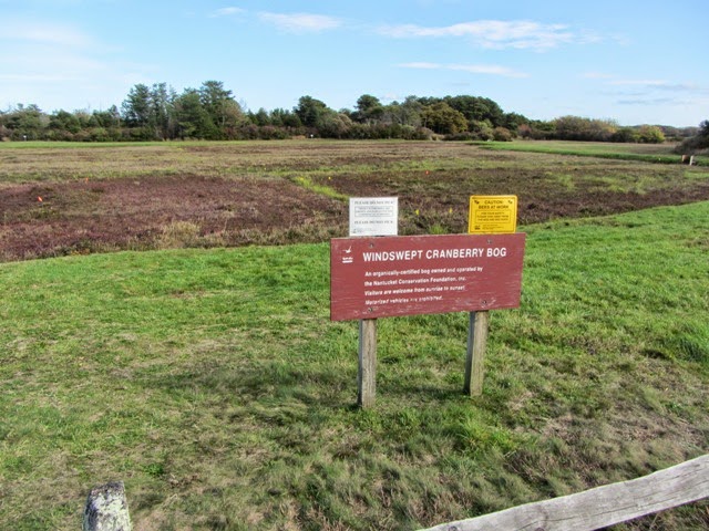
... and the path was quite pretty, especially as it wound by a cranberry bog and through a small pine forest.
Just like on the Milestone Road Bike Path, sandy roads veered off into the interior of the island. This one was guarded by a pair of very attentive Foo Dogs:
The Polpis Path was long and hilly though, and the scenery wasn't as dramatic as the Milestone Road Path. Add in persistent headwinds from the west and this became a pretty challenging ride. But I'm glad I chose the route-less-traveled, and soon enough the path led me back to the town of Nantucket.
I leisurely explored its beautiful residential streets...
... and walked my bike around the shops and galleries of the town center.
This dog was living the good life, sleeping outside an art gallery.
And what would a northeast seaside town be without a Fudge Shop!
With about 45 minutes to go before my homeward ferry arrived, I decided to take a short bike ride out to Jetties Beach. Riding to where the road disappeared into the sand, I looked out toward the Nantucket Sound, and there I caught an amazing sight:
My approaching ferry, the Eagle, seemingly floating on the horizon as it made its way to Nantucket's Steamship Authority terminal. Beautiful.
Riding back to town...
... I watched as the now-docked ferry unloaded its trucks, cars, and passengers...
... and then I climbed on board and sat in a comfortable booth -- but only for a few moments! As the ferry steamed out of the harbor and the sun began to set over Nantucket and the ocean, I walked out into to chilly evening air onto a side deck to enjoy the show.
Returning to the warm interior of the ferry, I settled back into a booth and put my helmet and bag on the table and my Brompton on the floor next to me. I tried to take a picture of the night sky with my iPhone, but it turned out to be a silhouetted self-portrait in the window's reflection.
I loved the two-hour voyage back to Cape Cod. I ordered a hot chocolate, read, enjoyed the view out the window, and simply rested -- weary after a day of riding, but so content and inspired by my journey.
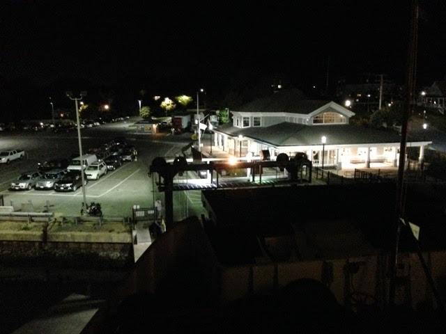
As the Eagle approached Hyannis' Steamship Authority Terminal, I went outside to the windswept front deck and watched as the gigantic ferry gracefully cruised into its mainland home.
(The spotlight in this photo is coming from the ferry itself, illuminating the way to the dock...)
And with the now-familiar thud of the ferry making contact with the port, I arrived back on Cape Cod. I carried my Brompton, helmet, and bag off the boat, and then stopped for a moment to see the trucks and cars re-emerge from the hold one last time.
As one of the ferry workers waved goodbye to some people on the dock...
... I walked to my nearby Zipcar and loaded the happy Brompton into the trunk. Looking back once more on the exquisite nocturnal scene of the ferry preparing for its final journey across the Nantucket Sound, I drove out of the Steamship Authority parking lot and turned the car north, toward Boston.

.JPG)
.JPG)
.JPG)
.JPG)
.JPG)
.JPG)
.JPG)
.JPG)
.JPG)
.JPG)
.JPG)

.JPG)
.JPG)
.JPG)


.JPG)


.JPG)
.JPG)

.JPG)


.JPG)


.JPG)

.JPG)


.JPG)